36/498
)
)
)
)
)
)
)
)
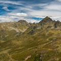
, Grubenspitze (2671m), Hochstadel (2681m), Gamsköpfe (2695m), Große Sandspistze (2772m), Große Keilspitze (2739m), Mokarspitz (2305m), Kristallspitz (2401m), Rotwieland (2555m), Scharnik (2657m), Torwand (2562m), Drischaufeleck (2577m), Kreuzlhöhe (2624m) vom Knoten")
Böses Weibele (2599m), Grubenspitze (2671m), Hochstadel (2681m), Gamsköpfe (2695m), Große Sandspistze (2772m), Große Keilspitze (2739m), Mokarspitz (2305m), Kristallspitz (2401m), Rotwieland (2555m), Scharnik (2657m), Torwand (2562m), Drischaufeleck (2577m), Kreuzlhöhe (2624m) vom Knoten
- Copyright
- Creative Commons (BY-SA)
- Autor
- Martin Fux
- Napravljen na
- Utorak 23 Avgust 2022
- Objavljeno u
- Nedelja 18 Septembar 2022
- Datoteka
- 22-D02-011.jpg
- Tagovi
- Landscape, season:Summer
- Kategorije
- Poseta
- 562
- Location
- In OpenStreetMap ansehen
- Rezultat ocenjivanja
- bez ocene
- Oceni ovu sliku
- Modell
- NIKON D750
- Belichtungsprogramm
- Zeitautomatik
- ISO
- 100
- ApertureFNumber
- f/7.1
- Belichtungszeit
- 1/125 s
- Belichtungsabweichung
- 0.0 EV
- Brennweite umgerechnet auf 35mm Film
- 40 mm
- Blitz
- no, Modus: unterdrückt
- iptc_description
- Böses Weibele (2599m), Grubenspitze (2671m), Hochstadel (2681m), Gamsköpfe (2695m), Große Sandspistze (2772m), Große Keilspitze (2739m), Mokarspitz (2305m), Kristallspitz (2401m), Rotwieland (2555m), Scharnik (2657m), Torwand (2562m), Drischaufeleck (2577m), Kreuzlhöhe (2624m) vom Knoten
- iptc_city
- Oberberg
- iptc_sublocation
- Oberberg
- iptc_county
- Kärnten
- iptc_countryiso
- AUT
- iptc_country
- Österreich
0 komentari
Dodaj komentar