27/145
)
)
)
)
)
)
)
)
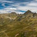
, Grubenspitze (2671m), Hochstadel (2681m), Gamsköpfe (2695m), Große Sandspistze (2772m), Große Keilspitze (2739m), Mokarspitz (2305m), Kristallspitz (2401m), Rotwieland (2555m), Scharnik (2657m), Torwand (2562m), Drischaufeleck (2577m), Kreuzlhöhe (2624m) vom Knoten")
Böses Weibele (2599m), Grubenspitze (2671m), Hochstadel (2681m), Gamsköpfe (2695m), Große Sandspistze (2772m), Große Keilspitze (2739m), Mokarspitz (2305m), Kristallspitz (2401m), Rotwieland (2555m), Scharnik (2657m), Torwand (2562m), Drischaufeleck (2577m), Kreuzlhöhe (2624m) vom Knoten
- Copyright
- Creative Commons (BY-SA)
- Údar
- Martin Fux
- Erstellt am
- Dé Máirt 23 Lúnasa 2022
- Veröffentlicht am
- Dé Domnaigh 18 Meán Fómhair 2022
- Datei
- 22-D02-011.jpg
- Schlagworte
- Landscape, season:Summer
- Alben
- Besuche
- 556
- Location
- In OpenStreetMap ansehen
- Bewertung
- noch keine Bewertung
- Foto bewerten
- Modell
- NIKON D750
- Belichtungsprogramm
- Zeitautomatik
- ISO
- 100
- ApertureFNumber
- f/7.1
- Belichtungszeit
- 1/125 s
- Belichtungsabweichung
- 0.0 EV
- Brennweite umgerechnet auf 35mm Film
- 40 mm
- Blitz
- no, Modus: unterdrückt
- iptc_description
- Böses Weibele (2599m), Grubenspitze (2671m), Hochstadel (2681m), Gamsköpfe (2695m), Große Sandspistze (2772m), Große Keilspitze (2739m), Mokarspitz (2305m), Kristallspitz (2401m), Rotwieland (2555m), Scharnik (2657m), Torwand (2562m), Drischaufeleck (2577m), Kreuzlhöhe (2624m) vom Knoten
- iptc_city
- Oberberg
- iptc_sublocation
- Oberberg
- iptc_county
- Kärnten
- iptc_countryiso
- AUT
- iptc_country
- Österreich
0 tuairimí
Einen Kommentar hinterlassen